Showing posts with label Google Maps. Show all posts

Monday, 6 August 2012

Mappy Monday - working at Somerset House


In the census you occasionally come across a description page for an enumeration district like the one above in 1851, which includes a sketch map of the district as well as a list of the streets it contains. I found this one while I was working on one of my pet projects, the story of the people who worked for the General Register Office at Somerset House. 
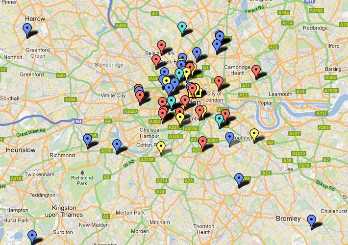
I have been able to find some of these men in the census, and where I could identify them on a modern map of London I have plotted them using Google Maps. I created a map which I have called General Register Office staff. Each marker represents a member of staff in a particular census year, and its tab shows the man's name, the census year, his address and his post in the GRO at that time.
The markers are also colour-coded 1851  red, 1861 - blue, 1871 - pale blue, 1881 - yellow. It's an ongoing project, so not all census years are included yet, and I also need to do more work to locate some addresses where the street names have changed, or where the streets have disappeared altogether. 

I found the census map particularly interesting because the one of the streets shown, Chapel Street, was the home of the Registrar General at the time, George Graham.  

Print

Tuesday, 1 May 2012

Mappy Monday - Collections on a map


This is the latest feature to be released on The National Archives Labs and you can use it to locate several kinds of local history resources. You can search by place or by document type to get the full reference, and in the case of the Early Maps and the two photograph collections you can see an image too. The collections you can search are:

This illustration shows the result of a search with 5km of Wootton Wawen in Warwickshire, revealing some tithe maps, school files and a few photographs, including two of Henley-in-Arden. One of the school files is a Building Grant Application for Wootton Wawen National School (Ref ED 105/53/19 p397); I may have a look at it one day, because I attended that school for a year in the early 1960s.


These records are local history rather than obvious family history resources, but my justification for including them in my family history blog is that good family historians should be interested in local history too. There are some useful guides on a number of local history resources, including schools, villages, monastic lands and more on The National Archives Looking for a place page.

 Print

Monday, 12 December 2011

Mappy Monday - 'Locating London's Past' website

If you liked the Proceedings of the Old Bailey and London Lives then you'll just love Locating London's Past. By way of explanation I can't do any better than quote the introductory paragraph from the site's own homepage.
This website allows you to search a wide body of digital resources relating to early modern and eighteenth-century London, and to map the results on to a fully GIS compliant version of John Rocque's 1746 map.
 Rocque's wonderful 1746 set of maps is a pretty accurate survey of the metropolis at that time, but lacking the kind of technology we have today it's not going to be pinpoint accurate. The map was overlaid on a modern Ordnance survey map by 'pinning' them together at 48 fixed points on the Rocque map that are still in existence today, and adjusting the old map to fit the new one. If my low-tech explanation fails to satisfy, you can find out exactly how this was done on the Mapping Methodology page.

You can use information from a number of datasets to plot all kinds of things on either of the historic maps, a modern map, Google Maps satellite view or even a blank background. I can see all kinds of applications for this; one of my particular pet projects is to map the locations of the various taverns and coffee houses where the notorious 'Fleet' marriages took place, and this site should be a big help with that.

There are plans to add a citable search URL, map export function and citation generator. They also hope to add more maps and datasets in the future, which will make it even better. In the meantime there is plenty to explore, and there is a video walkthrough to help you find your way around. You can also send suggestions and feedback through the Contact Us page. I'm sure that people will come up with plenty of applications relevant to their own research.

 Print