Showing posts with label Maps. Show all posts

Monday, 19 March 2018

Comparing BMD indexes for England and Wales: Ancestry


There are separate databases for:

England & Wales, Civil Registration Birth Index, 1837-1915 (free index)
England & Wales, Civil Registration Birth Index, 1916-2005
England & Wales, Civil Registration Death Index, 1837-1915 (free index)
England & Wales, Civil Registration Death Index, 1916-2007
England & Wales, Civil Registration Marriage Index, 1837-1915 (free index)
England & Wales, Civil Registration Marriage Index, 1916-2005

There is another database ‘England and Wales, Death Index, 2007-2015’, but this does not come from GRO data.

The six databases can be searched individually, and there is an option to search all of the above databases at once, called ‘England and Wales, Birth, Marriage and Death Indexes, 1837-2005’ For some odd reason this category also includes six databases of church records from Derbyshire, Somerset and Wiltshire, and the search fields seem more suited to parish register searching.

The wider category ‘Birth, Marriage & Death, including Parish’ includes all of the above, plus more than 300 related collections such as church registers and probate calendars and obituaries, from all parts of the British Isles. However, even the ‘one size fits all’ search screen for this category has a lot of options for refining a search. No category is mandatory, and each field can be set to ‘exact’ or a variety of flexible options. 

Search options


When searching a single database you can select ‘Exact’ for any search field, which enables the use of wild cards * at any point in the word. An ‘Exact’ search in the forename field will return all the results where that name appears, even as a middle name - so a search for Mary will return results for Mary Ann, but there seems to be no way to confine the search to Mary without any other forenames. Leaving the ‘Exact’  box unticked for a name field searched using name variants, which can be useful, but there is no way of knowing which variants have been included or excluded.

You can select an exact year, or up to + or - 10 years. There is a drop-down menu for the month - although the results are always in quarters up to 1983. If you select January, February or March you will get results for the March quarter, and so on. The place search options are less helpful; there is just the standard Ancestry place option, which auto-fills to places in its worldwide database. This does not include a number of registration districts, and even when override this by typing the exact name of one of these ‘missing’ districts it returns no results. This is likely to happen with a district name which is not also the name of a parish or town within it; for example, ’Medway’ will return no results, but ‘Medway, Kent’ will return results from every district in Kent.

Search results


When searching across multiple databases, there are two ways of viewing the results; the ‘Records’ tab lists all of the individual results from all the categories, and the ‘Categories’ tab shows a list of the databases with results, and the number of results in each. 

The results within each database come in chronological order by year (not by quarter) and alphabetically within each year. They show the name, registration district and a county (which does not appear in the original index, and is not always accurate) You can also view an image of the original index page. Each result also has a shopping cart symbol where you can order a copy of the certificate, but this is NOT RECOMMENDED because it costs more than twice as much as ordering direct from the GRO, and will take longer.

The layout of the results varies a little between the various databases, but have similar features, and if you click on ‘View record’ against a particular entry, you will see them all. These include a full transcription of the entry and a link to the original index page (up to 1983). Results from the marriage indexes 1837-1915 include the all the names with the same volume and page reference, to help you identify likely spouses.

If you search the birth indexes by surname, but without a forename, the results from 1911 onwards include entries under other surnames, but where the surname you are searching is the mother’s maiden name. There is no way of searching by mother’s maiden name only in the 1837-1915 birth indexes, but the search options for the 1916-2007 database includes a ‘Mother’ field, for the mother’s maiden name. 

The original paper version of the marriage indexes from 1912 include the surname of the spouse, but the Ancestry results helpfully include the full name of the spouse. 

Death indexes include an age at death from 1866, which in the Ancestry results appears as an estimated year of birth eg ‘abt 1840’ but ‘View record’ shows the age as it appears in the paper index. Results 1837-1915 appear in chronological order, which may not be obvious at first, because it is in order of estimated year of birth, except where the age at death does not appear in the indexes, in which case the year of death is used instead, in practice for results from 1837 to 1865. 

There is no way to re-sort or download search results, although you can choose how many to show at a time, 10, 20 or 50. You can also widen your search to other sets of databases without re-entering the search data. This can be useful where a result from another category helps you identify the right entry - for example a probate calendar entry for a death, or the parish register copy for a marriage.

Phillimore Atlas and Index of Parish Registers 


All of the 1837-1915 indexes include a feature which could have been brilliant, but sadly, has been badly executed.
Extract from the Kent parish map
The full record includes a hyperlink ‘View Ecclesiastical Parishes associated with this Registration District’ which takes you to a list of parishes, based on information extracted from the excellent Phillimore Atlas and Index of Parish Registers. Against each parish is a link to the Atlas’s map for that county, and a simple grid reference to locate the parish within the map, eg 5G, 3A etc. If you look at these maps in the book version of the Atlas you will see that the county maps aren’t overlaid with an actual grid, but have letters and numbers in the margin, which works very well as a visual guide, without cluttering the map with extra lines. The Ancestry parish lists have painstakingly included all these references, but unfortunately, the numbers and letters have been cropped from the images of maps, so you have to guess where they might have been. Oops!


There are some transcription errors, but a much bigger problem is the way that the parishes are listed in their registration districts; if the name of the district contains more than one word, the list will show all the parishes in districts which contain any of those words. So the link for the registration district of St George in the East goes to a list of parishes in districts all over the country, including St Martin in the Fields, Newcastle in Emlyn, Stow on the Wold, and Bury St Edmunds, to name but a few. 

Browse options


The search options and the way the results are presented leave much to be desired, but on the plus side, it is very easy to browse the original index pages. The main search page for each database has a browse option on the right-hand side where you select a year, a quarter, and then an initial letter; so you can reproduce the experience of using the old born index volumes, but without the heavy lifting.

The links to the Phillimore Atlas maps are not very helpful in this context, but they do contain a lot of useful information, and you can browse the map images, either by following the links from your search results, of from the Atlas’s own landing page. 

Print

Monday, 6 August 2012

Mappy Monday - working at Somerset House


In the census you occasionally come across a description page for an enumeration district like the one above in 1851, which includes a sketch map of the district as well as a list of the streets it contains. I found this one while I was working on one of my pet projects, the story of the people who worked for the General Register Office at Somerset House. 

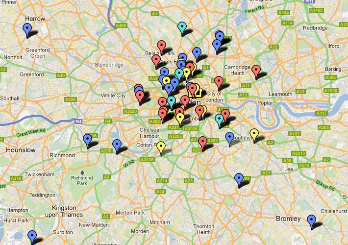
I have been able to find some of these men in the census, and where I could identify them on a modern map of London I have plotted them using Google Maps. I created a map which I have called General Register Office staff. Each marker represents a member of staff in a particular census year, and its tab shows the man's name, the census year, his address and his post in the GRO at that time.
The markers are also colour-coded 1851  red, 1861 - blue, 1871 - pale blue, 1881 - yellow. It's an ongoing project, so not all census years are included yet, and I also need to do more work to locate some addresses where the street names have changed, or where the streets have disappeared altogether. 

I found the census map particularly interesting because the one of the streets shown, Chapel Street, was the home of the Registrar General at the time, George Graham.  

Print

Monday, 9 April 2012

Mappy Monday - London Railways

New Railway Map of London & Suburbs (Bacon's Atlas 1890)
Some of the most heavily used maps today are railway maps, and in particular those for major cities like London. Tourists in London know that they can always find their way around using the famous London Underground map. In fact, some never venture onto the much bigger network of buses because they feel so comfortable with the familiar colour-coded diagram. You see it all over the place as a decorative item, it has become such a design classic. You can even see it online and download it (and several others) from the Transport for London website.

The map above is its ancestor, although it doesn't look very similar to the modern map. Many of the lines and stations from the modern London Underground network are clearly shown, but there is no distinction between the 'underground' and 'overground' networks as there is today. Many of the modern-day underground stations that you can see on this map appear as part of the Metropolitan and District Line, although today you will find them on the Metropolitan, Circle, District and Hammersmith & City lines. Anyone familiar with the London Underground will see that the Piccadilly, Northern, Central, Victoria and Jubilee lines are under-represented; the Victoria and Jubilee Lines date only from the late 20th century, while those parts of the other lines that run under central London use tunnels deep below the ground, which had not been dug when this map was produced in 1890. The ones that you can see here are of the comparatively shallow 'cut and cover' type.

Metropolitan Railway 1870
This picture dates from 20 years before the map, and depicts part of the Metropolitan Railway. I don't know which station it is, but it looks an awful lot like Baker Street (I've spent an awful lot of time waiting for trains there over the last 30 years, so I should know!).

One of the most striking differences, though, is that the modern 'map' isn't really a map at all, it's a diagram, and isn't at all to scale. When it is drawn to scale it doesn't look at all familiar, so you can have fun comparing the two, but it may not be as easy as you think. If you look closely you will see that the railway lines are overlaid on a very faint street map, although you have to have pretty good eyesight to read most of it. Enjoy.

 Print

Monday, 30 January 2012

Mappy Monday - Evacuation map of Scotland 1939

TNA ref: RG 26/6

A National Register was compiled throughout the United Kingdom in September 1939, on the outbreak of the Second World War. The information collected was used for a variety of purposes; identity cards, ration books, conscription into the armed forces and other services, and the evacuation of children. There is a great deal of background information in The National Archives about the administration of the system. Many of the documents can be found online at HISTPOP and there are some interesting details about the evacuation of children, including the map of Scotland, above. There is no corresponding map for England and Wales, but there is a county list. Every county was designated either as an evacuation area, from which children were to be removed, a neutral area, or a reception area.

Links to the evacuation papers and other documents on National Registration can be found on the HISTPOP page Documents relating to National Registration, 1939

 Print

Tuesday, 17 January 2012

Mappy Monday - Middlesex electoral map 1845


Middlesex 1845

The London and Middlesex electoral registers recently released on Ancestry.co.uk have attracted quite a lot of attention, so this seemed like a good time to bring out this map. It is an electoral map of Middlesex in 1845, showing the polling  places, indicated by a cross, and those boroughs entitled to elect two members of parliament, indicated by a black circle. The MPS elected by the boroughs were in addition to the members elected by the whole county. 

This was after the Reform Act of 1832, which reflected for the first time the notion that the number of MPs returned should have some correlation with the size of an area's population. There was still a long way to go, though; it was a step in the right direction, but we had moved from 'hardly anyone can vote' to 'a few people can vote'. You still had to be a) an adult male and b) the occupier of property over a certain value, to vote in parliamentary elections. There were different rules for local elections, and women could vote in these depending on the date and the place. 

Another notable feature of elections until 1872 was that there was no secret ballot. Voting meant declaring publicly your choice of candidate, or candidates. From the candidate's point of view this had the advantage that if you bribed someone to vote for you, they couldn't double-cross you by voting for the other man and pocketing the money anyway. Sometimes you will find the record of votes cast recorded and published in poll books. These can be very revealing if you find one for an election where your ancestor voted.


Great Stanmore 1851: LMA MR/PEO/1851/4/3 (Image from Ancestry.co.uk)

Although very few people could vote in the earlier years, it can still be worth looking at the register for the place where your ancestors lived. I called my earlier post 'Who was Stanmore Groat?' because it was a mis-rendering of the name of the parish of Great Stanmore. It was a small place, and it isn't marked on this map, but it is close to Edgware, which is shown. Edgware is on the east side of the road and the two Stanmores, Great and Little, are on the west side. Great Stanmore's population in 1851 was 1180, but there were only 22 voters, and half of them didn't even live in Great Stanmore, they just held property there. If you look at the printed register it tells you quite a bit about the place, and you will see names of some occupiers who are not voters, so you shouldn't assume that these early electoral registers are of no interest to you because your ancestors were not among the voting classes.

You can find registers for a place by browsing the collection, and while the drop-down menu claims to be a list of boroughs, you will see that it also includes three counties; London, Middlesex and Surrey. Some of these interesting early registers are found under 'Middlesex' where they should be, but most are in 'London' which didn't exist as a county until 1889. Never mind. I may talk about the whole London/Middlesex thing sometime, if I can summon the strength.

While most of the registers are later in date, and from 1889 you are much more likely to find you ancestors in them, but please don't neglect the early ones. It is worth the effort of negotiating your way through Ancestry's characteristically eccentric means of classification to find them. 

 Print

Monday, 2 January 2012

Mappy Monday - Strange Maps

This is an interesting site if you like maps that are a little out of the ordinary. It was the most recent post the Underwritten States of America that caught my eye, but there are lots of other intriguing links in the 'Recent posts' section. I particularly like the Alphabet Maps of Great Britain and Ireland

You can also search the blog archive of more that 500 posts, or browse back, post by post. There are a number of comments attached to each post, and these can make interesting reading too. For example, one on the Underwritten States of America page suggests that it is for the purposes of life insurance, rather than health insurance, which I am inclined to agree with.

 Print

Monday, 12 December 2011

Mappy Monday - 'Locating London's Past' website

If you liked the Proceedings of the Old Bailey and London Lives then you'll just love Locating London's Past. By way of explanation I can't do any better than quote the introductory paragraph from the site's own homepage.
This website allows you to search a wide body of digital resources relating to early modern and eighteenth-century London, and to map the results on to a fully GIS compliant version of John Rocque's 1746 map.
 Rocque's wonderful 1746 set of maps is a pretty accurate survey of the metropolis at that time, but lacking the kind of technology we have today it's not going to be pinpoint accurate. The map was overlaid on a modern Ordnance survey map by 'pinning' them together at 48 fixed points on the Rocque map that are still in existence today, and adjusting the old map to fit the new one. If my low-tech explanation fails to satisfy, you can find out exactly how this was done on the Mapping Methodology page.

You can use information from a number of datasets to plot all kinds of things on either of the historic maps, a modern map, Google Maps satellite view or even a blank background. I can see all kinds of applications for this; one of my particular pet projects is to map the locations of the various taverns and coffee houses where the notorious 'Fleet' marriages took place, and this site should be a big help with that.

There are plans to add a citable search URL, map export function and citation generator. They also hope to add more maps and datasets in the future, which will make it even better. In the meantime there is plenty to explore, and there is a video walkthrough to help you find your way around. You can also send suggestions and feedback through the Contact Us page. I'm sure that people will come up with plenty of applications relevant to their own research.

 Print

Tuesday, 2 August 2011

Mappy Monday - Registered for marriages

Here are a couple of maps that form part of my favourite document. Yes, I really do have a favourite item in The National Archives' collection, which came in handy when I was asked that very question in a job interview; well, I got the job anyway, so it can't have done any harm. The document in question is a book, mostly handwritten but with some pasted-in printed material. According to its Catalogue description it is a 'Record Book' in the extensive collection of General Register Office papers. It is not dated, but from the contents it seems to have been compiled during the 1880s. It is a compendium of useful reference information relating to the work of the office since its beginnings in 1837.

There are several hand-drawn maps, and I find this pair particularly interesting because they illustrate something that I don't think I've seen in map form anywhere else. Using information in the printed Official List of 1881,each  maps illustrates 100 registration districts. The first shows 100 districts where there were more churches (of the Church of England) licensed for marriages than there were Dissenting Chapels registered for marriages. The second map illustrates the opposite; 100 districts where there were more Dissenting Chapels registered for marriages than Church of England churches licensed for marriages. In both cases each church is represented by a black dot and each chapel by a red dot. The red ink was probably much brighter in the 1880s, but now it has faded to a shade of brown, so it does not stand out so well against the black dots. Despite this, the maps still provide a good visual rendition of the relative popularity of nonconformity throughout England and Wales.

The dots represent only churches or chapels, however, and give no indication of the size of their congregations, or of the actual number of marriages performed. The first map seems to show that East Anglia was a great stronghold of the Established Church, but the explanation of this cluster probably has more to do with the area's history than its 19th Century present. Norfolk and Suffolk were much more populous and prosperous in the Middle Ages than in the 1880s, relatively speaking. The population had actually decreased during the 19th century, as people moved to the industrial areas of the Midlands and the northern counties, and of course to London. But the churches didn't move with them. Today East Anglia is still full of small towns and villages with magnificent medieval churches, built for the much larger congregations of an earlier age.

Details like this might be interesting to explore further, and all the required statistics are in the Annual Reports of the Registrar General. Some other time, maybe.

100 districts with more churches of the Established Church licensed for marriages than Dissenting Chapels registered for marriages in 1881  

100 districts with more Dissenting Chapels registered for marriages than churches of the Established Church licensed for marriages  in 1881

Print

Tuesday, 12 July 2011

Mappy Monday - British Isles industries


I didn't realise that I had this map; I came across it when I was looking for something else, often the best way of finding things. It's a fold-out from 'Cassell's Encyclopaedia: a Storehouse of General Information'. The encyclopaedia comprises six volumes, with some very high quality illustrations and maps. Unfortunately there is no publication date, but the contents suggest it is c1900.

It reminds me of some the maps from the geography books we had at school, and you don't see this kind of map very much outside of specialist historical atlases. That's a pity, because a visual representation is much more memorable than any amount of text, especially if you are not familiar with the British Isles.

Print

Monday, 4 July 2011

Mappy Monday Miscellany

Manchester Town Hall
I have recently come across some online map resources that were previously unknown to me, all different, and all interesting.

Continuing the alliteration theme a little further, the first is a blog post from Manchester Archives, looking for help in pinpointing the exact locations of the pictures in its collection. You need a flickr account to contribute, but if you just want to look at the 3000 photographs that have been uploaded, you just need to follow the link on the blog. Another link takes you to the first 50 mystery photographs that await geo-tagging . The picture on the right isn't one of them, since the pictures on the Manchester Archives site are, very reasonably, protected by copyright.

A very different kind of site covers the whole of the UK and Ireland, and is not run by an institution, but by enthusiasts - quite literally. SABRE stands for Society for All British and Irish Road Enthusiasts  and the the site includes a number of uploaded maps. Unlike many historic map sites, it concentrates on the 20th century. The maps images are of a very high quality, but when I first used the site I thought some of them were missing. In fact, when you open up some of the maps the image is out of range of the screen, so you may need to use the pan and zoom controls to find it; irritating, but hopefully something that will be fixed in due course.

Finally, the Strange Maps blog is unlike any other map site I have seen. It has all the quirkiness and variety of Bostonography, but the maps are of places all over the world, as well some fictional ones. I'm off to look at the blog archive; I may be gone some time...

Nebraska-shaped field in Nebraska posted 8 Dec 2009

Print

Monday, 20 June 2011

Mappy Monday - Panorama from the top of Snowdon


Wales is the only part of the UK in which I have no personal or family interest, so I sometimes feel that I may be neglecting it. I haven't even visited Wales since the 1960s, although I have had some terrific views of South Wales from the air - it looks wonderful in the morning sunlight at the end of an overnight flight from the USA.

So I was pleased to find that I had an interesting 'map' in one of my books. The book in question is Baedeker's Great Britain 1901, a pocket sized volume of nearly 600 pages, including a number of maps and  some plans of major cathedrals. This is the only panorama, though. I've never seen, or at least I've never notices, a mountain panorama before, although I've seen panoramic views of London and other cities. I find the view to the west particularly interesting, with views of Anglesey, the Isle of Man and Ireland.

This is what Baedeker has to say about the panorama:
The view from the top of Snowdon, though scarcely so wild and grand as some of the mountain-panoramas of Scotland, is very extensive and varied, including the greater part of North Wales, a wide expanse of sea, and upwards of twenty lakes and tarns. The view at sunrise or at sunset is particularly fine; but the summit is often swathed in mist for days at a time. The mist, however, is not always an unmixed evil, as some of the finest effects are caused by its surging or dispersal
I made as good a scan of the panorama as I could, without damaging it or the book, as the binding is fairly tight. The book is in pretty good condition, apart from a small tear to one of the fold-out maps and a slight scuff on the binding. I can't remember what I paid for it, but it wasn't a lot. Definitely one of my best bargains.


Print

Monday, 30 May 2011

Mappy Monday - Maps you can play with

I have featured a number of interesting maps here, often from my own collection, and I have plenty more where they came from, but I thought I'd look at something different this time.

England Jurisdictions 1851 (FamilySearch)
It's great to be able to put a map or image online for everyone to share, but some sites do much more than that. My favourite map sites are the interactive ones, where you can zoom in and out, compare maps of different dates, click on hot-spots and so on. Many of use Google Maps, where you can go almost anywhere in the world, and explore much of it using Street View. You can use it to get directions, too; handy if you are (like me) too cheap to invest in SatNav. But have you used Google Earth? You need to download and install the software on your computer, but it is truly interactive; you can explore in even more detail than Google Maps, create your own maps and tours, and upload your own contributions. As well as viewing 3-D buildings, you can create and upload your own using a free program, Google SketchUp (which has all kinds of other design applications too - there's a thief of time if ever I saw one!)

If you are interested in something more focussed than maps of the entire world (and beyond - Google Earth goes to the Moon, too), there is plenty to choose from. I think the first online map site I ever saw that compared historic and modern maps was the Charles Booth Online Archive which compares the famous London poverty maps from 1889-1890 with the modern street map. A more recent site which does even more with old and new London maps is London Low Life  where you can see 27 historic maps of London, the earliest from 1788. Each of these is overlaid with a modern map, and a slider bar you can use to reveal as much or as little of the old map as you wish. This site also has a thematic map where you can see the changes in the size and density of London's population between 1801 and 1890, and the sites of hospitals, workhouses, prisons and more. It even has its own Victorian version of Street View, in the form of Tallis's Street Views, a series of very detailed engravings of some of London's main streets in 1838-1840. This is an absolutely unmissable site for anyone interested on London history.

London Remembers is a well-constructed site devoted to London's memorials. It is based on a Google Map, which you can search by the names of individuals (real and fictional), events or institutions. There is an intriguing 'Puzzle Corner' feature, where the site's creators are looking for help with identifying or interpreting some of the memorials and illustrations. They have a sense of humour, too. I particularly liked their disclaimer:   Caveat: Be aware that London actually has many more cars, fewer bikes, more rain and less sun than our photos show.

London is not the only served by imaginatively designed map sites. Cheshire's e-mapping Victorian Cheshire project contains nearly 500 tithe maps from around 1839-1851, together with their accompanying apportionments. You can search by name of owner, occupier, parish, township and even some field or plot names. You can view the results as a list, which you can download as a spreadsheet, or on a map. The map view shows the tithe map alongside a modern map of the same area, and you can zoom in and out on both of them at the same time. Don't you wish you had ancestors in rural Cheshire? Or if you have, lucky you.

Returning to the wider world, Historypin is a collaborative site where users are encouraged to attach their own historic photographs an stories to a Google map. You need a Google account to participate, which is free to set up, and you don't need to have a Google email to do do this. And returning to the present day, Openstreetmap is an editable street map 'The Free Wiki World Map' as it describes itself. But if you want a site with more features, and that has genealogical applications, you can register with Ancestral Atlas free of charge to share your genealogical data in a map-based format. You can enter details individually, or upload a GEDCOM file, and control how much of your information is made public. You can get access to additional features and an advert-free version of the site for a one-off subscription of £20. Ancestral Atlas links to another of my favourite sites a Vision of Britain through time for extra contextual infromation, and if you haven't explored this site already, then you really should! Another essential interactive map site for English genealogy is of course the FamilySearch England Jurisdictions 1851

Finally, here is an interesting collaborative project at Geograph to photograph every square kilometre of Great Britain and Ireland, which is 78.8% complete as of today - any offers?

Print

Thursday, 14 April 2011

Those Places Thursday - London docks

St Katherine's Dock

The area round London's docks has always been busy and crowded, with people who lived there, and even more who were just passing through. Long before the railways or decent roads, the Thames was London's highway, and nearly all the goods that came into the capital city, even from other parts of England, came in through the docks at its eastern end.

This map of the Port of London describes the area from St Katherine's Dock and the Tower of London all the way downriver to the East India Docks. It covers areas like Stepney, Limehouse and Poplar on the north bank, and Bermondsey, Rotherhithe, Deptford and Greenwich south of the river.

These places were populated by people who depended on the river and the docks for their living, going back many centuries. They left plenty of evidence of their lives and activities, in parish registers and other records.

You can find out a lot about these people at Parishregister.com, the website of Dockland Ancestors Ltd. Although it is a commercial site with books, maps, CDs and look-ups for sale, there is lots of background material and links to other useful sites. Many of the parish register indexes can also be searched on Findmypast.co.uk

Many of these will also be found on Ancestry.co.uk as part of their London Parish Registers collection. They also have some Poor Law Union records, which are not searchable by name, but can browsed.


The family history societies for this part of London are the East of London Family History Society for the area north of the river (Middlesex), the East Surrey Family History Society for Bermondsey and Rotherhithe, in the modern borough of Southwark (Surrey), and the North West Kent Family History Society for Deptford and Greenwich (Kent). That should be enough to keep you going for a while!

Such a busy port needed a lot of customs officers, and if your ancestors were among them you can find out about their records in The National Archives. None of the records is online, but there is a Research signpost that will tell you where to start researching.

But if you want background information about the place itself and its history, the Port Cities - London site is full of it. There are chapters on all kinds of themes, with a collection of images and even a 'virtual pub crawl'. How can you resist that?

Print

Monday, 11 April 2011

Mappy Monday - around Edinburgh

Edinburgh street plan 1877

With the release of the Scottish 1911 census last week, Scotland has been uppermost in my mind recently. Since I have no plans to visit Edinburgh in the immediate future, some maps are the next best thing. 

I have just scanned many of the illustrations from 'Black's Guide to Scotland', which include a number of maps. The large map at the top is a street plan of the whole city, and the others show what the guides considers the most interesting parts is more detail. 

Edinburgh Castle 1877
The castle is of course Edinburgh's most famous feature, and therefore merits a map of its own. If you look closely you will see that the detail includes the castle's famous gun, Mons Meg.

Calton Hill 1877
 Calton Hill is at the eastern end of the city centre, and while this map shows some interesting features of Edinburgh it just misses one of its most interesting ones;  one the left-hand side of the map you can see the caption 'Register House', but the building itself is just outside the frame. This is the building that now houses the ScotlandsPeople Centre, and for the genealogist this is the real centre of Edinburgh.

Greyfriars Churchyard 1877
The detailed plan of Greyfriars Churchyard points out what the Guide considers to be the most significant graves. It is easier to find it on the main map when you realise that the top of the this map is east, not north.

Edinburgh University and Museum 1877
  This map shows the City Chambers, St Giles cathedral and the old Parliament House as well as the university and museum, and is turned even further round from the norm, with south at the top of the map.

Between them, these maps tell us a lot about what Edinburgh was like in the late nineteenth century, except for one important thing; the route from any point A to any point B in Edinburgh is always uphill, and when you go back again it's still uphill.


Print

Tuesday, 5 April 2011

Mappy Monday - some links


Instead of digging a map from my own collection, I thought I would link to some map and map-related sites instead. Here are a few of my favourites, in no particular order.

Historypin

Digital collections of historic maps

Maps for research (UK)

Old Street Plans (UK)

A vision of Britain through time

London: a life in maps

MAPCO (London)

Booth poverty maps (London)

Maps of Scotland

Historical Map & Chart Collection (USA)

Library of Congress map collections

Bostonography

I put this list together in a few minutes, from my favourites list. Maybe you'll find something here you didn't know about before - I hope you find something you like. But if you want to read an article by someone who really took some time and trouble over it, I recommend:

Mapping out the past, a post from Kith and Kin Research (aka Luke Mouland).

Print

Tuesday, 29 March 2011

Mappy Monday - with extra detail


This is one of the maps in 'Philips Handy Volume Atlas of London' which has no publication date, but a hand-written inscription in the front is dated 1922. The pages are not very big - as you'd expect for a 'handy' volume, but they are beautifully detailed, and in colour, too. It has some of the usual maps that you sometimes find in London atlases, like railway maps, small scale maps of London environs and birds-eye views. This is one of the ordinary pages, showing part of the City of London, including St Paul's Cathedral, and part of Southwark, on the south bank of the Thames.

But this atlas also has some extra detail, which you do not find in most street atlas volumes; it has ground plans of London's two great cathedrals, St Paul's and Westminster Abbey. They also qualify as maps, because they show the surrounding streets too. Here is the plan of St Paul's to complement the map above.


Print

Monday, 17 January 2011

Mappy Monday - Chatham


This in an odd little map that I picked up several years ago, because I have an interest in the area covered by it; I lived in Gillingham and went to school in Chatham. I bought the map as a single sheet, and it is undated - like most maps of this kind it probably came from a book, and there is no clue to its provenance on the map itself. My guess would be that it comes from the early 19th century, or thereabouts, from the extent (or lack of it) of the built-up areas.

A number of features are indicated on the map, from two forts, Gillingham and Fort Pit, to a brick kiln and an oil mill, and even a pub, the Star, in the bottom right corner. The small cluster of dwellings that constituted Gillingham, and the even smaller Upnor are also shown, as are a few road names. But what interests me most is the lack of any label for arguably the most significant feature of the whole map, Chatham Royal Naval Dockyard. This is the area just to the north-west of the word 'Brompton'.

Although there is no key to the map, the faint dotted lines represent the parish boundaries, indicating 'part of Gillingham parish' and 'part of Chatham parish'. If you look closely you will see that the boundary between the two runs through the middle of the dockyard, so that part of Chatham Dockyard isn't in Chatham at all, but in Gillingham. The population of this are grew enormously during the 19th century, along with the growth of the dockyard itself, a major source of employment in the are until the late 20th century. In 1848 the completely new parish of Brompton was formed from parts of Chatham and Gillingham parishes, encompassing the whole of the dockyard, so that no part of it was in the parish from which it takes its name. Nowadays Brompton, including the dockyard, is part of Gillingham - a nice little piece of geographical trivia, which might come in handy in a pub quiz one day, you never know

Tuesday, 11 January 2011

Mappy Monday - a census oddity


This map is a lucky find, from a source where you would not normally expect to find maps.

Every enumeration book in the census has a page at the start, giving a brief (sometimes very brief) description of the area covered. In rural areas it might just say 'The whole of the parish of...' and leave it at that. In towns there is usually a list of the streets included, and sometimes a description of the route followed by the enumerator. The more recent the census, the greater the amount of detail is likely to be provided. But what you will rarely see is a map of any kind.

It can often be difficult to work out the exact boundaries of an enumeration district just from the written description, and the enumerators sometimes got it wrong themselves. This is why you will occasionally find a household enumerated twice in the same census, where two enumerators believed that the house was in their patch, so both delivered schedules, and the occupants dutifully completed both. Enumerators were not provided with maps, but I have seen some examples where they drew a rough sketch map to explain the area covered. If you are very lucky, as in this case, some helpful person will have provided a good clear map of the district; this might be the enumerator himself, or the local Registrar who organised the taking of the census in all the enumeration districts in the his area. We shall probably never know.

This map is for part of Marylebone in central London, close to Regents Park. It has been cut from a printed map, and the area covered by this enumerator is indicated by a heavy black line, with the list of streets written neatly at the side. I'm not too sure about the little stick-man drawing, though; it has a very 20th century look to me. If you compare this map with a modern one, the street plan is still recognisable, and the little stick man is on the site now occupied by Lord's Cricket Ground.

Monday, 20 December 2010

Mappy Monday - London, a birds-eye view


This map comes from the Pocket Atlas of London 1896, one of the many old books lining the walls of my house (and very good insulation they are, too). I published a reprinted version of this atlas some years ago, but because of the cost, it was in black and white. The level of detail is amazing, considering that the original is only about 12cm high and 18cm wide. It does look better in colour, though.


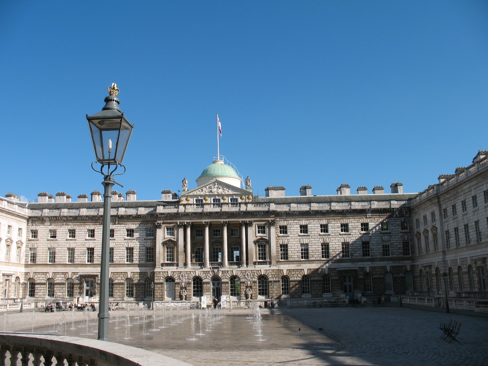
This is an enlarged view of the centre part of the map showing, among other famous landmarks, Somerset House. This was the home of various public offices over the years, but is probably best known as the home of the General Register Office, which left there in 1974. Today it houses a museum, and the unlovely car park in the courtyard has been replaced by fountains in summer, and an ice rink in winter

Somerset House in 2010